3D-Modelling a Late Medieval Field System at Ballygillin 1, Co. Westmeath
By Ian Russell of Archaeological Consultancy Services Unit
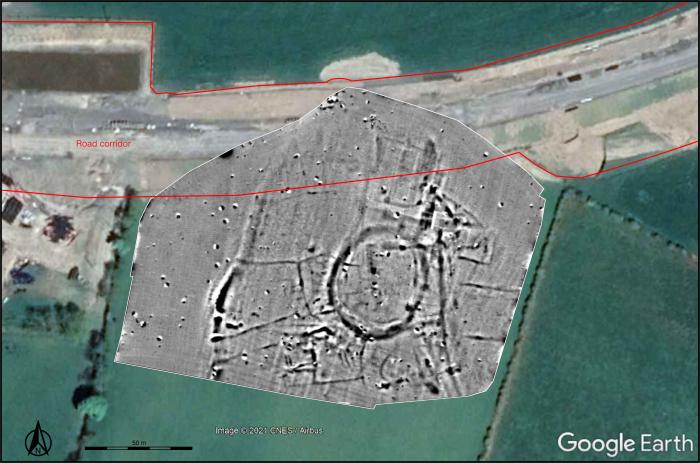
In the townland of Ballygillin, situated between Delvin and Mullingar in County Westmeath, a geophysical survey undertaken in July 2018 by Target Archaeological Geophysics focused on the area surrounding a previously recorded enclosure (Record of Monuments and Places No. WM013-095). There are no visible traces of this site above ground, but it is evident as a faint cropmark on aerial photographs and it had been depicted as a circular area on an 1833 estate map of Ballykilinn (Ballygillin) and Williamstown, which belonged to Edward Briscoe. The geophysical survey revealed that this enclosure formed a focal point around which an extensive field system developed. Subsequent archaeological testing identified three ditches related to this field system.


Geophysical survey results showing the field system around the central ditched enclosure (WM013-095) south of the new N52 Cloghan–Billistown road (Target Archaeological Geophysics). Top: Greyscale image overlying 2020 aerial photograph (Google, © 2021 CNES/Airbus) and depicting the extent of the road corridor. Bottom: Interpretation image showing the excavated area within the road corridor.
While the enclosure was beyond the corridor of the proposed N52 Cloghan–Billistown Phase 2—Turin to Billistown Realignment, the northernmost area of the newly discovered field system, 60 m north of the enclosure, was within the road footprint and therefore subject to an archaeological excavation. This was carried out in October 2018 under the direction of the author for Archaeological Consultancy Services Unit (ACSU) on behalf of Archaeological Management Solutions Ltd.
Three ditches forming part of this extensive field system were exposed, fully excavated and recorded. The largest ditch was curvilinear in plan and appeared to form the eastern and northern portion of an animal or crop enclosure. Abutting this was a north–south ditch, which most likely formed part of an internal division within this field enclosure. The third ditch extended north-west to south-east and also formed part of an internal field boundary. Charcoal, charred seeds, animal bone fragments, occasional metal artefacts and some medieval pottery sherds were found in these ditches. Based on the types of pottery recovered and a radiocarbon date from a cattle tooth, a 13th–14th-century date is most likely for this complex.
A cereal-drying kiln had also been constructed at the base of the curvilinear ditch. This was probably selected as a favourable location to protect the kiln from wind and rain. A small number of charred cereal grains were recovered from this feature. Some of these were identified as naked wheat, one of which was radiocarbon-dated to the early 15th–early 17th century.
More detailed information on the archaeological discoveries at Ballygillin can be found in the scheme StoryMap—Past lifeways in the Irish Midlands—and the excavation report can be accessed via the TII Digital Heritage Collections.
To assist in preserving the site by record and to aid any future research that might be undertaken on the enclosure and its associated late medieval field system, a three-dimensional (3D) model of the excavated area was created.

Stills from the 3D model of the excavated section of the late medieval field system at Ballygillin, Co. Westmeath. From top-left clockwise: looking south-west, south, north-east and north (Ian Russell, ACSU).
This digital recording was carried out by the author using a type of computer software that processes digital photographs to generate 3D models. This is a form of digital visualisation that is being employed more and more by archaeologists to help them record heritage sites. The model was created with Reality Capture software using 211 photographic images in .jpeg file format. Using a Phantom 3 Pro aerial drone, a series of video and still images were taken around the circumference of the site at varying heights until a full 360-degree record of the excavation area was recorded. This included ensuring that each image had a sufficient (20–25%) overlap.
Once captured, the images were fed into the Reality Capture software and automatically and manually aligned using markers to illustrate which points in each image overlapped with its corresponding photograph. Once aligned, the software created a dense point cloud and mesh, showing a rough outline of the site. Following editing and corrections, the software then produced a textured model by incorporating texture and colour from the images. The 3D model was saved in .fbx file format and inputted to Sketchfab—a web-based platform for viewing 3D models—where additional corrections were made to lighting and texture. The finished model can be viewed in Sketchfab.
(Posted 20 August 2021)