A New Dimension to a 19th-century Limekiln in Liscromwell, Co. Mayo
By Richard Gillespie, Agnes Kerrigan, Ian Russell and Siobhan McNamara
Limekilns are the most widely distributed and numerous industrial site-type in the Irish landscape. They are depicted on 19th-century Ordnance Survey (OS) maps as a small circle with a darkened portion defining the stoke-hole, but are generally not named. A cursory survey of first- and second-edition OS six-inch maps reveals a widespread distribution of limekilns throughout rural Ireland. Many farmsteads had their own small kiln or a group of farmers may have used a communal limekiln to serve their needs. A 19th-century limekiln at Liscromwell, Co. Mayo, was excavated by Siobhan McNamara of ACSU Ltd in December 2016, along a new section of the N5 national road. This kiln was associated with a small group of houses and was one of a number of kilns depicted in the townland.

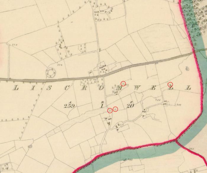
Extract from the first-edition Ordnance Survey (OS) six-inch map showing a number of limekilns (circled in red) in the townland of Liscromwell, Co. Mayo. The excavated kiln is located further to the south and is possibly later in date than those depicted here (Reproduced with the permission of the Government of Ireland and Ordnance Survey Ireland under permit number EN0045216).
Limekilns were generally constructed of stone and built into a bank or hill, which allowed easy access to the upper opening for filling with limestone and turf. Limekilns were usually circular in plan, although rectangular or square kilns are known. The interior was gently curved to ensure the lime did not adhere to the walls and may have been plastered using a mix of fine sand and lime, which had to be replaced after several uses. A stoke-hole, known as a púirín or poucheen, at the base of the front wall allowed for the kiln to be fired and the lime to be removed. A stone lintel was placed over the opening to carry the stone wall.

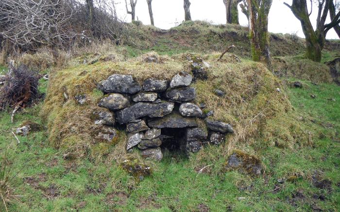
The Liscromwell limekiln prior to excavation (Photo: Mayo County Council).
There were two basic forms of limekiln: the intermittent kiln and the continuous type. The most common form was the continuous type, in which fuel and limestone were placed in the kiln together for burning. (The kiln excavated at Liscromwell was of this variety.) The fuel and limestone was constantly replenished over two to three days and then allowed to cool. The intermittent type, in which the fuel and limestone were generally separated, provided an ash-free, purer product. This was achieved by the construction of an arch or floor of limestone between the main bowl of the kiln and the firing area. The larger intermittent type was filled only once, the limestone/fuel fired and then left to burn, and was not replenished during the firing. The lime was then removed before the kiln was re-used. The continuous type usually had a grate/iron bars placed inside it in a line across from the stoke-hole. The grate separated the firing area from the limestone and fuel above, and allowed the lime to fall through for removal.
Extract from the 1940–50 edition of the OS six-inch map showing the location of the limekiln excavated in Liscromwell (circled in red). Note the absence of the kilns to the north-east, by the townland name, originally depicted on the first-edition map (Reproduced with the permission of the Government of Ireland and Ordnance Survey Ireland under permit number EN0045216).
Turf was the main fuel type, however, charcoal, coke and wood were also used. Temperatures inside a kiln needed to reach 900–1200 ºC and it took up to 48 hours for all the limestone to be reduced to lime. The limekiln was filled with alternate layers of turf and limestone which had been broken into small pieces to aid the burning process. The bottom layer of turf was then lit and as the limestone and fuel burnt, more layers were added to the kiln until it was full of lime. The kiln was allowed cool for two to three days before being emptied and the lime placed in bags or barrels for sale or home use.
Calcium carbonate is the main component of limestone and forms calcium oxide (quicklime) when burnt. When exposed to water the lime is converted into calcium hydroxide in a process known as slaking and results in slake lime or hydrated lime. Slake lime mixed with sand produces mortar for stone building. There were a myriad of other uses for lime once it had been processed. It was used extensively in rural Ireland for plastering and rendering under slates, whitewashing walls and rafter timbers, in fowl houses to kill lice and to prevent disease, spread over animal carcasses to aid decomposition, and spraying potatoes when mixed with bluestone and washing soda. Other uses included shaking lime over the sprouted potatoes a few days before sowing, whitewashing trees trunks to prevent slug and insect damage, and annually adding a bucket of lime to the well to purify the water. On a more industrial side, lime was used to purify the town gas supply, as a flux in blast furnaces, in the production of bleaching powder and soda, and for the de-hairing of animal hides in the tanning process.
The Liscromwell limekiln consisted of a drystone walled oval structure measuring 3.1 m in diameter north–south, 2.9 m in diameter east–west, and 1.55 m in height. The walls were 0.25 m in thickness to the east and south, 1.0 m in thickness to the north, and 1.25m in thickness to the west. The kiln was constructed from roughly hewn, undressed limestone, with no bonding or mortar visible. A lintelled stoke-hole, measuring 0.38 m in width by 0.51 m in height, was present in the west face. An air channel capped with limestone flags was exposed at the base of the kiln, within the charging bowl. It was orientated west–east and measured 0.3m in width and 0.1 m in depth, and extended out at the base of the stoke-hole. Access to the kiln pot or charging bowl was gained by a 3 m-wide ramp cut into the side of a glacial ridge at the rear of the kiln and a roughly metalled pathway extended east from the kiln, providing access to the stoke-hole.

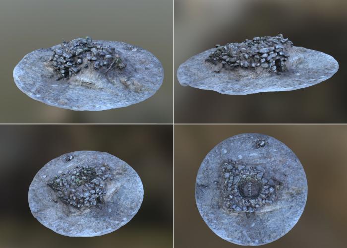
Stills from a 3D model of the Liscromwell limekiln created by Ian Russell of ACSU Ltd.
Archaeologist Ian Russell created a three-dimensional (3D) model of the Liscromwell kiln using a type of computer software that processes digital photographs to generate 3D models. This is a form of digital visualisation that is being employed more and more by archaeologists. The model was created with Agisoft Photoscan (Professional Edition) using 321 photographic images in .jpeg file format. Using a Nikon D90 DSLR camera, the images were taken around the circumference of the kiln at varying heights until a full 360-degree record of the kiln sides and top was recorded while ensuring that each image had a sufficient (20–25%) overlap. Imagine placing an enormous upturned fish bowl over the kiln and taking enough photographs to cover every portion of it so that you can’t see through the glass.
Once captured the images were fed into the Agisoft Photoscan software and automatically and manually aligned using markers to illustrate which points in each image overlapped with its corresponding photograph. Once aligned, the software created a dense point cloud and mesh, showing a rough outline of the kiln. Following editing and corrections, the software then produced a textured model by incorporating texture and colour from the images. The 3D model was saved in .fbx file format and inputted into Sketchfab—a web-based platform for viewing 3D models—where additional corrections were made to lighting and texture. The finished model can now be viewed in Sketchfab.
Further reading
Egan, E 1994 ‘Limekilns: a way of life in a rural community’, in Drum Heritage Group, Drum and its hinterland, 307–11. Drum Heritage Group, Drum.
Gillespie, R & Kerrigan, A 2010 Of Troughs and Tuyères: the archaeology of the N5 Charlestown Bypass. NRA Scheme Monographs 6. National Roads Authority, Dublin.
O’Hara, B 1991 The Archaeological Heritage of Killasser, Co. Mayo. GMIT Research and Development Unit publications, Galway.
O’Sullivan, M & Downey, L 2005 ‘Lime kilns’, Archaeology Ireland, Vol. 19, No. 2, 18–22.
Rynne, C 2006 Industrial Ireland 1750–1930: an archaeology. The Collins Press, Cork.
(Posted 29 November 2017)